The most complete guide to Crete: 221 places on the map, 23 routes and 49 articles — with photos, videos and the story behind every place. No sign-up, no trackers.
Routes drawn along real roads
Weather at every stop
Full-text search
“Near me” by geolocation
Create your own printable itinerary
Satellite, terrain, dark mode
Works offline
⌕
Searches 1.7 million characters of descriptions, not just names
—places
4regions
—routes
—with video
Search results
—
Interactive map
Find what is near you
Filters narrow the map and the list at once. Zoom out and pins group together.
Region
Category
Фильтры карты
Landmarks
Featured places
RegionCategory
Routes
Ready-made day trips
Individual places
Articles about landmarks
Roussospiti – a village of Venetian country houses
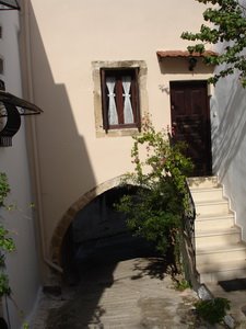
Roussospiti (Ρουσσοσπίτι) lies at about 300 metres on the northern slope of Mount Vrysinas, which rises to 858 metres; it is between six and nine kilometres from Rethymno, depending on the route taken. The road climbs through wooded country, past the monastery of St Irene, and leads into a village where Venetian doorways, arches, fountains and old country seats have held their own among modern houses; the place is officially listed as a traditional settlement. The most striking building is a three-storey manor house with a vaulted passage running beneath it, through which the lane passes – one of the most expressive examples of secular architecture from Venetian Crete. Some of the façades carry carved gondolas and dolphins. Because of the view over the town, the Fortezza and the sea, local people call the village the “balcony of Rethymno”.
The place enters the written record in the Venetian registers of 1577 and 1583, which give it 157 inhabitants; the Turkish census of 1659 lists 24 houses. A wall is said to have once protected the inhabitants from corsairs. For a long time the village lived on oil, wine and a little grain, and for much of the 20th century it was shrinking: the census counted 372 people in 1913, 353 in 1951 and only 257 in 1991. More recently it has been sought after as a place to live at the gates of the town and has grown markedly – from 374 inhabitants in 2001 to 569 in 2011, and 536 in 2021.
The church of the Presentation of the Virgin and the chapel
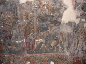
The church of the Presentation of the Virgin in the Temple, in the lower village, was the first parish church of Roussospiti; local accounts take it back to the 12th or 13th century, while the small single-cell building as it stands is generally assigned to the early 14th. Its wall paintings are attributed to an unknown Cretan master. The surviving fragments, finely executed, still reveal the pictorial language of a church painting closely bound to the Orthodox tradition of the island; the Crucifixion, with its figure of Christ on the Cross, is counted among the most vigorous works of its kind in Crete. But they also bear the marks of history: in Ottoman times the church was desecrated, the eyes of the saints were gouged out with lance points, and in 1896 the building even served as a coffee house. In 1898 the villagers, on their return, restored the church and had it enlarged by the master builder Daskalakis.
Right beside it stands a small Venetian chapel of the 17th century, built of porous tufa. Its Corinthian capitals – forms of ancient origin reinterpreted by the architecture of the Renaissance – set it apart from the ordinary buildings of the village and show that Roussospiti grew up at the meeting point of Orthodox tradition and Venetian building culture. The village also preserves a stone fountain of the 17th century, a graceful piece whose spout is shaped as a lion’s head – the lion being the emblem of St Mark and of the Venetian Republic. It recalls the everyday side of history, a time when the water supply was part of public space and the fountain was the meeting place of the village.
Cave chapels, the Lygeri cave and the summit of Vrysinas
The surroundings repay a walk. On the slope north of the village the chapel of St Onouphrios is built into a cave in the rock. Water drips from the stone into a basin whose level, local people are convinced, always stays the same, and which is regarded as holy water; the chapel holds the bones of a hermit who lived here. The saint, to whom miracles are ascribed, is celebrated on 12 June. Other small shrines lie in the two gorges and on the crags around the village: Agios Antonios (feast on 17 January), the rock chapel of Agios Georgios to the south (23 April) and Agios Nikolaos (6 December).
About 500 metres to the south-west is the mouth of the Lygeri cave, with stalagmites and stalactites; its main passage is said to be some 250 metres long. The name – “the slender girl” – is explained in one legend by a tall young woman who lost her life in the cave, in another by a woman fighter. Those who climb further reach the chapel of the Holy Spirit on the summit of Vrysinas. It stands on the site of an important Minoan peak sanctuary – apart from the finds at Chania the westernmost Minoan site yet known – where numerous small clay figurines were found, together with miniature vases, a fragment of a stone offering table inscribed in Linear A and, unusually, an eagle’s talon and several boar’s tusks; on Whit Monday the people of the surrounding villages make the pilgrimage to the top. The mountain owes its name to the many springs (βρύσες) on its flanks.