The most complete guide to Crete: 221 places on the map, 23 routes and 49 articles — with photos, videos and the story behind every place. Everything is open and free: no sign-up, no paid sections and no advertising, open or hidden. You can install the guide on your smartphone as an app.
Routes drawn along real roads
Weather at every stop
Full-text search
“Near me” by geolocation
Create your own printable itinerary
Satellite, terrain, dark mode
Works offline
⌕
Searches 1.7 million characters of descriptions, not just names
—places
4regions
—routes
—with video
Search results
—
Interactive map
Find what is near you
Filters narrow the map and the list at once. Zoom out and pins group together.
Region
Category
Фильтры карты
Landmarks
Featured places
RegionCategory
Routes
Ready-made day trips
Individual places
Articles about landmarks
Georgioupoli on the River Almyros
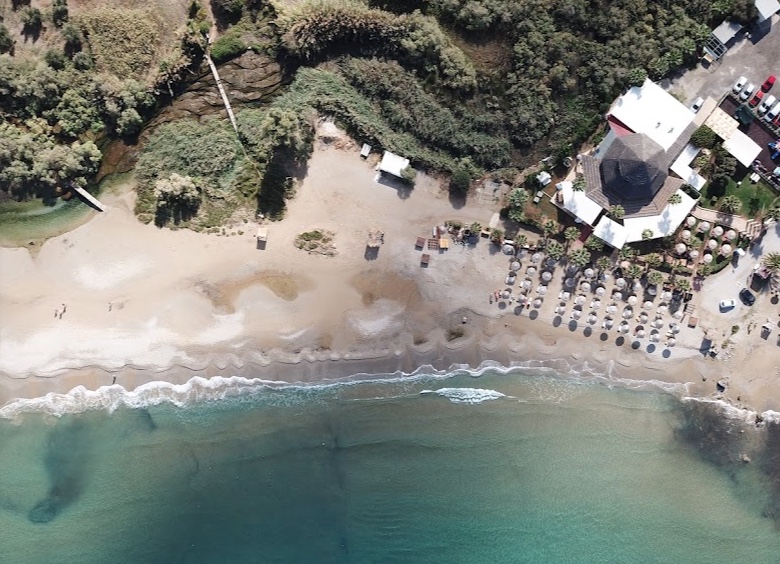
From Vamos the road drops by way of Kalamitsi and Exopoli to Georgioupoli (Γεωργιούπολη), a coastal village at the innermost point of Almyros Bay, some 38 kilometres east of Chania and a little over 20 kilometres west of Rethymno, on the boundary between the two prefectures. The village grew up where the Almyros reaches the sea, in a green, well-watered plain threaded by rivers and springs; three streams in fact meet the sea here, the Almyros being the largest, and just upstream of the houses it widens into a reedy pool that is alive with birds. Sandy beaches now run along the shore – eastwards almost ten kilometres as far as Kavros and Kournas beach, where an extensive belt of dunes survives – lined with tavernas, restaurants and hotels. The central square, shaded by tall eucalyptus and cypress trees and ringed with coffee houses, remains the heart of village trade and of the evening stroll, and in the small river harbour, marked by a toy lighthouse in white and blue, lie the fishing boats and the excursion craft. The old road in from Vrysses enters the village along a long avenue of eucalyptus. Buses from Chania and Rethymno call throughout the year.
From marshy lowland to seaside resort
The district has been inhabited since Minoan times; Minoan tombs have been found on the hill of Kastelos, together with a number of votive objects. In antiquity the settlement on the hill of Venou Kefala was Amphimalla (also recorded as Amphimalion), the harbour of the city of Lappa, the present Argyroupoli up in the hills to the south-east, and near the shore, in the locality of Agia Kyriaki, the remains of a three-aisled early Christian basilica survive with traces of painted decoration. In the early Byzantine period the area was abandoned. In the 13th century the Venetians recognised the value of the bay and built two small forts, the Kastelakia or Paliokastela – the Castello dell’Almiro of their documents – which were kept permanently garrisoned; one of them outlasted the Ottoman conquest and stood at the northern edge of the village until the rising of 1821, when Cretan insurgents under Protopapadakis destroyed it. The river was formerly navigable, and its mouth gave shelter to small craft.
Until the end of the 19th century, however, the mouth of the Almyros was a waterlogged, almost uninhabited and fever-ridden tract. The first settler is held to be Miltiadis Papadogiannakis, a merchant from the nearby village of Kalamitsi who had made his money in Athens: in 1880 he began draining the marshes and turning the plain into farmland, using the river water for irrigation. The eucalyptus trees that still give the village its character date from the same enterprise – hundreds of them were planted in 1893, the year the first settlers moved in, because these fast-growing Australian trees draw great quantities of water from the ground and were widely used across the Mediterranean to dry out malarial swamps.
The settlement was originally called Almyroupoli – “town of the Almyros”; the river’s name means “the salty one” and refers to the brackish water of the springs close to the coast, where sea water seeps into the limestone and mingles with the fresh. In 1899 it was renamed Georgioupoli in honour of Prince George, the first High Commissioner of the autonomous Cretan State (1898–1906), on the occasion of his visit to Chania and in anticipation of the union with Greece that most Cretans expected to follow. The name thus records the island’s political history after its liberation from Ottoman rule. The community has grown slowly: a little over 600 residents were counted in 1991, and about 840 in 2021, though in summer the population is many times that.
The chapel of St Nicholas in the sea
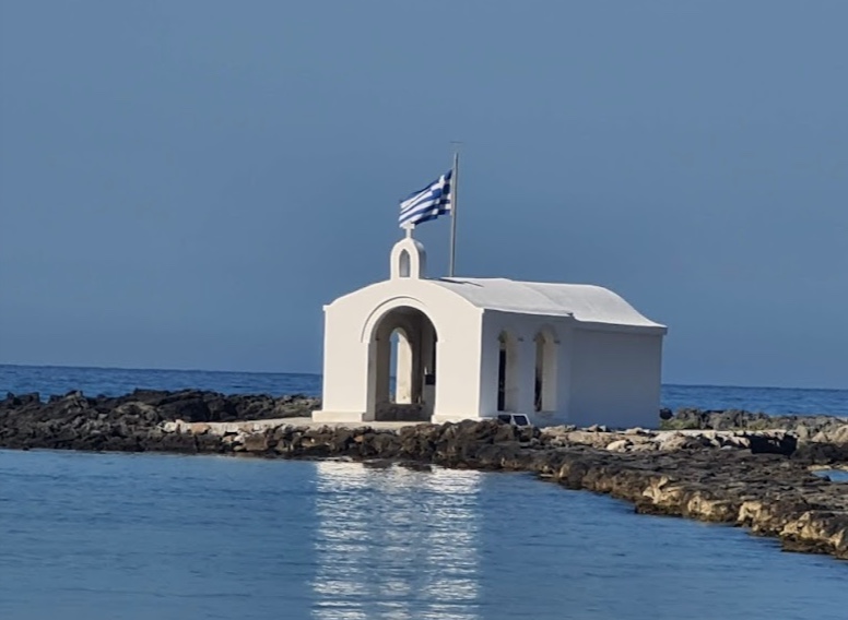
Georgioupoli’s best-known landmark is the white chapel of St Nicholas (Agios Nikolaos), standing on a small rocky islet off the mouth of the Almyros. A narrow causeway of heaped rubble now leads out to it, and in rough weather the waves break across it; formerly the chapel stood on a solitary rock in open water, and it still seems to hover on the surface of the sea – the islet has been joined to the shore for the better part of a century. According to local tradition a seaman built it in fulfilment of a vow, asking St Nicholas, the patron of sailors, to watch over those at sea. It is the most photographed sight in the harbour, and the walk out along the mole, with the fishing boats on one side and the open bay on the other, is best taken in the early morning or towards sunset, when the light falls on the white walls; in a northerly swell, sensible footwear and a steady step are needed on the wet stones.
Pirates and the old narrows of the Almyros
Before the present village was founded the coast was shunned because of pirate raids. The narrow passage at the river mouth was long considered a dangerous place and served as a refuge for smugglers and robbers; after the Venetian fort was pulled down in 1821 there was nothing to police it, and the strait became unsafe for honest traffic. The chapel of St Nicholas is therefore seen not merely as a picturesque landmark but as a sign of protection over the seaway.
Georgioupoli combines the amenities of a holiday resort with the landscape of the river, the marshy lowland and the old bay. In the first decades of the 20th century the settlement developed as an administrative centre, declined around the middle of the century, and began to grow again when European travellers discovered Crete in the 1970s; the former fishing village is now a town of cafés, tavernas, small hotels and apartment blocks, and the seat of a municipal unit of Apokoronas with some 2,700 inhabitants in its villages. Alongside tourism the local people still live by fishing, farming and bee-keeping. Families favour the shallow, sheltered beach of Kalyvaki, west of the river mouth at the far end of the bay; the main beach runs about two kilometres east from the harbour before passing into Kavros. At the river mouths the water is noticeably colder, since the springs feed the streams all year round, and where rivers enter the sea currents can form – children should keep away from the channel itself. From Georgioupoli it is an easy excursion to Lake Kournas, the island’s only freshwater lake, some four kilometres inland and reached on foot, by bicycle or by the little tourist train; its ancient name was Koresia, and the eels it was once known for have given way to terrapins. Vamos, Kalamitsi and the other villages of Apokoronas are within equally easy reach.