Temenia: mineral springs, ancient Hyrtakina and the church of Christ the Saviour
The most complete guide to Crete: 221 places on the map, 23 routes and 49 articles — with photos, videos and the story behind every place. No sign-up, no trackers.
Routes drawn along real roads
Weather at every stop
Full-text search
“Near me” by geolocation
Create your own printable itinerary
Satellite, terrain, dark mode
Works offline
⌕
Searches 1.7 million characters of descriptions, not just names
—places
4regions
—routes
—with video
Search results
—
Interactive map
Find what is near you
Filters narrow the map and the list at once. Zoom out and pins group together.
Region
Category
Фильтры карты
Landmarks
Featured places
RegionCategory
Routes
Ready-made day trips
Individual places
Articles about landmarks
Temenia: springs, Hyrtakina and the church of the Saviour
Temenia (Τεμένια) is a mountain village in the municipality of Kantanos–Selino, in the west of the Chania region and some 62 kilometres from the city of Chania. It takes in the old hamlets of Tsanoudiana, Mesa Chorio and Lazopouliana; together they make up a village of few permanent residents – about forty – with olive groves and traditional stone building, set high in the hills at 700 metres and more. Temenia owes its importance to the meeting of springs, an ancient archaeological heritage and medieval churches. The name, too, points to the past: temenos was the ancient Greek word for a sacred precinct set apart for a deity.
Temenia is known for its mineral water. The spring was given the official status of a recognised natural medicinal resource and in 2021 was entered in the register of the Greek Ministry of Tourism, by ministerial decision no. 2053; the municipality had applied for renewal of the recognition in 2017, after an earlier one had lapsed. It is the only spring in Crete so classified. This is a natural mineral water and a tradition of taking the waters; what medical use makes sense in any particular case is a matter for specialists alone.
The water emerges cool, at a little over 18 degrees, is slightly acidic and contains chiefly sodium, chloride and bicarbonate, together with calcium, magnesium, potassium, iron and sulphate. The flow is modest – about one and a half cubic metres an hour. It was recognised for bathing and drinking cures for complaints of the musculoskeletal system, rheumatic disorders and skin diseases. The name of the village is in any case familiar throughout the country: a private firm, founded in 1954, has long bottled soft drinks here – lemonade, orangeade, soda water, cola – that are sold all over Greece.
Hyrtakina on the hill of Kastri
Above Temenia, on the scarcely accessible height of Kastri at about 900 metres, between Temenia and the village of Papadiana, lie the remains of ancient Hyrtakina (Υρτακίνα). The city came into being in the Archaic period and flourished in Hellenistic times. It was an independent community, a polis, which commanded the mountain routes between Selino and the south coast, struck its own coins – one type shows the Cretan wild goat and a bee, another a dolphin and an eight-rayed star – and in the 3rd century BC belonged, together with Elyros, Lissos, Tarra and other neighbours, to the League of the Mountain People, with whom it shared a monetary union. It is also recorded as an ally of Eumenes II of Pergamon. Among ancient writers the city is named by Ptolemy and Stephanus of Byzantium, but it is the Periplus of Pseudo-Scylax that says most about where it stood. In Roman times Hyrtakina gradually declined.
Sections of massive walls, remains of the acropolis and traces of sanctuaries survive. There were two circuits of rough polygonal masonry, running along the north and west sides for rather more than 800 metres; elsewhere the hill falls away so steeply that no wall was needed, and the gateways were protected by flanking walls. Robert Pashley identified the ruins in the 19th century. A sanctuary on the eastern spur of the fortification was in use from Hellenistic times down to the 1st century BC; here a temple of Pan was discovered in 1938 and dug by Vasilios Theofanidis, and the acropolis yielded a headless marble statue of the god, of Roman date, goat-legged and wearing a mantle. The hill was thus at once the stronghold and the religious centre of the ancient city. From the top the view extends over the valleys of Selino to the Libyan Sea – it is clear at once why the city was founded on this spot.
The church of Christ the Saviour
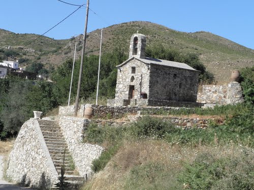
At the foot of the hill, in the hamlet of Lazopouliana, stands the church of Christ the Saviour – in Greek, Sotiros Christou. It was built in two stages: the first belongs to the 13th century, the second to the 14th. The frescoes are dated to the 16th and 17th centuries and show scenes from the life of Christ; their pictorial language also betrays Western influences of the kind that mark church painting in Crete under Venetian rule.
The building is a single-aisled, barrel-vaulted church; a narthex lies in front of the main space, and the walls are covered with paintings. A single monument thus brings together medieval architecture, later painted decoration and the present-day life of the parish. The archaeological hill of Hyrtakina and the spring are close at hand, so that one round on foot takes in antiquity, the Orthodox heritage and the natural landscape.
Temenia today
Temenia has remained a small mountain village, visited for the sake of the spring, the archaeological hill and the church of the Saviour. Before visiting church and spring it is advisable to ask whether they are accessible. The village can be reached from Paleochora in about half an hour, and the road goes on by way of Rodovani to Sougia or back to the coast through Azogires. There is scarcely another place where it is so plain how natural water, the history of an ancient polis and the Orthodox memory of the late Middle Ages exist side by side in a single landscape.