The most complete guide to Crete: 221 places on the map, 23 routes and 49 articles — with photos, videos and the story behind every place. No sign-up, no trackers.
Routes drawn along real roads
Weather at every stop
Full-text search
“Near me” by geolocation
Create your own printable itinerary
Satellite, terrain, dark mode
Works offline
⌕
Searches 1.7 million characters of descriptions, not just names
—places
4regions
—routes
—with video
Search results
—
Interactive map
Find what is near you
Filters narrow the map and the list at once. Zoom out and pins group together.
Region
Category
Фильтры карты
Landmarks
Featured places
RegionCategory
Routes
Ready-made day trips
Individual places
Articles about landmarks
The Imbros Gorge – a way through Sfakia
Imbros (Ίμπρος, in local speech also Nimbros) is a mountain village on a small upland at around 780 metres, on the road from Vryses to Chora Sfakion and a few kilometres south of the Askifou plateau. Here one can stop before the walk, eat and fill water bottles – there is no drinking-water spring in the gorge itself, and the bed is generally dry, with only a few rock basins, the Gournia, holding rainwater in winter. At the village begins the Imbros Gorge (in Greek Φαράγγι Ίμπρου), one of the most impressive and at the same time most easily walked gorges in the south of the Chania region, running roughly parallel to its larger neighbour; after the Samaria Gorge it is the most visited in Crete.
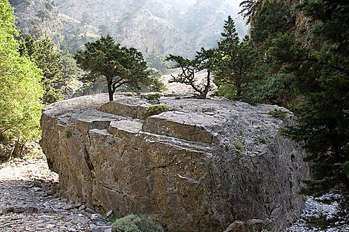
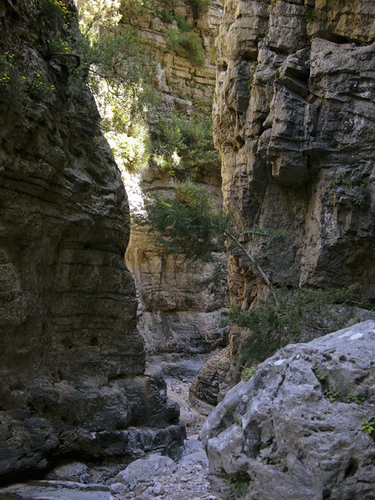
The walk takes two to three hours, according to pace, halts and the exit chosen. The gorge is seven to eight kilometres long, and the drop to the mouth at Komitades, which lies at about 200 metres, is a good 600 metres. The first stretch, known as Porofarango, is fairly broad; the walls close in after about an hour. The narrowest places are barely two metres across – at one point, the “Stenada”, only about 1.60 metres – while the vertical walls rise some 300 metres. Here and there the rocks all but meet above the path, forming a tunnel of stone. Almost throughout, the way is a smooth bed of water-worn stones with no technical difficulty, and it is therefore recommended to beginners and to families with children.
Water, plant life and the old road
In the middle section, at the place called Mesofarango, a Venetian cistern survives – the Venetsianiki Sterna – beside a guard’s hut and a shaded resting place. Walkers once drew their water from it; today it serves chiefly to water the donkeys and mules of the local people. The vegetation is dense in the upper part and thins out lower down; the last stretches pass among old cypresses, maples and the holm oak, a rarity in Crete, many of them rooted in the bare rock. Limestone walls, small caves and scrub growing straight out of the crevices give the gorge a constantly changing aspect, and in spring the ledges are bright with wild flowers. Beyond a further narrowing, the Gremnaria, and shortly before the exit, a natural arch of rock, the Xepitira, spans the path; it has become the emblem of the gorge.
Before there were motor roads, the gorge was the principal land route between the north of the island and Sfakia. Remains of the old paved mule track recall the time when villagers, pack animals and troops used it. Today the route forms part of the European long-distance path E4 and ends on the road between Chora Sfakion and Frangokastello, not far from the village of Komitades, where tavernas wait at the mouth of the gorge.
History and the memory of the 20th century
Imbros and its gorge have a settled place in the history of Sfakia. As early as 1821 the village was burned in the Ottoman campaign against the district. In 1867, during the rising of 1866 to 1869, women and children from the surrounding villages hid in the caves of the gorge; Ottoman troops discovered some of the refugees and killed them – local tradition holds that dozens of Sfakians were burned in one cave. A small wayside shrine on the path keeps their memory. In May 1941, after the Allied defeat in the Battle of Crete, almost twenty thousand soldiers – chiefly New Zealanders, Australians and British – fell back through the gorge to the south coast. From Komitades and Chora Sfakion they were taken off by sea to Egypt, some 13,000 of them in all; those who failed to reach the ships were taken prisoner or found shelter with the mountain people. The war left another trace in the upper gorge, at a spot still called the “Aeroplane”, where a German aircraft came down.
The village of Imbros lies on the upland of the same name and has kept its role as the northern gate of Sfakia. Local tradition connects the name with settlers from the island of Imbros in the northern Aegean, who came here towards the end of the 15th century. The made-up path begins at the village – the best-known way in is by a taverna on its southern edge; the walk to Komitades usually takes about three hours, though the time depends on pace, halts and the state of the path.