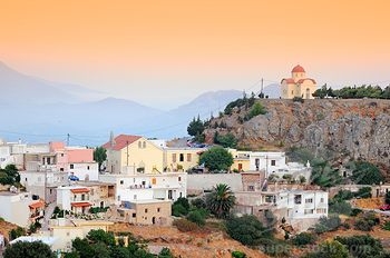
Sellia – the saddle village above the bay of Plakias
The most complete guide to Crete: 221 places on the map, 23 routes and 49 articles — with photos, videos and the story behind every place. No sign-up, no trackers.
Routes drawn along real roads
Weather at every stop
Full-text search
“Near me” by geolocation
Create your own printable itinerary
Satellite, terrain, dark mode
Works offline
⌕
Searches 1.7 million characters of descriptions, not just names
—places
4regions
—routes
—with video
Search results
—
Interactive map
Find what is near you
Filters narrow the map and the list at once. Zoom out and pins group together.
Region
Category
Фильтры карты
Landmarks
Featured places
RegionCategory
Routes
Ready-made day trips
Individual places
Articles about landmarks
Sellia above the Libyan Sea
The best approach to Sellia is by the mountain road that climbs the hillside above Plakias and the Kotsifou Gorge, crossing the stream by the bridge that bears the village’s name. From Rethymno it is about 32 kilometres. Stone houses, olive groves and pale limestone slopes compose a landscape characteristic of the south of Crete. From the two natural saddles on which the village sits the view reaches across the bay of Plakias and the bay of Souda to the open sea – on clear days as far as the island of Gavdos.
The village lies on the southern slopes of Xili (Ξυλή), a ridge rather more than 800 metres high which local people also call Kryoneritis, between the passes that link the coast with the villages of the interior; the E4 long-distance footpath climbs from the next village to the west, Rodakino, over these same heights. Its position accounts for both the name and the historical importance of the place: Sellia commanded the routes to Plakias and to the Kotsifou Gorge, and yet remained out of reach of raids from the sea.
History and church heritage
Early as Sellia appears in the Venetian registers, the village probably came into being earlier still, in the 12th or 13th century, when the inhabitants of several coastal settlements withdrew into the hills to escape the pirates and joined together on a safer site; its recorded history, like that of neighbouring Myrthios, is usually traced back to the 10th century. Some fifteen churches and chapels survive round about, many of them going back to Byzantine times. On the coastal strip between Finikias, Souda and Voukelaris remains of the Roman and Byzantine periods are attested as well.
The church of St Photios and the road to Plakias
Among the churches connected with Sellia are the parish church of the Dormition of the Virgin (Kimisi tis Theotokou), begun around 1880 and completed in 1886; the church of St George on the hill of Kastellos, which in its present form dates from 1977; and the Byzantine church of St Photios (Agios Fotios, in the village simply Ai-Fotis) to the east of the houses. The community regards it as the most important of its churches; tradition puts its foundation in the time of Nikephoros Phokas, who won Crete back for Byzantium in 961, entering the Arab capital of Chandax on 6 March of that year after a nine-month siege, and who later reigned as emperor from 963 to 969. Its wall paintings survive only in fragments, but the building remains an important witness to the middle Byzantine history of this district.
A village on the mountain road to the sea
Sellia is perched above the road that descends through the Kotsifou Gorge to Plakias and the south coast. The gorge begins at Kanevos as a cleft only about ten metres wide and opens out, over less than two kilometres, between walls some 600 metres high; a tiny chapel of St Nicholas is tucked into a hollow of the rock beside the road. This position gave the inhabitants access to fertile plots, to water and to the sea, and at the same time preserved the settlement from surprise attack from the coast. Anyone who steps out on to one of the two saddles at the edge of the village has Plakias, the bay of Souda and the Libyan Sea spread out as if on a map; the effect is at its most striking in the late afternoon, when the sun bathes the limestone slopes in warm light.
Sellia in the age of the revolts
In 1866 the revolutionary assembly of the Cretans met at Sellia. Many of the villagers took part in the rising of 1866 to 1869; for the fighting of 1867 the village chronicle names 143 men of Sellia, and the village is said to have provided 23 captains in all during the struggles for freedom. Pavlos Savvakis and Georgios Plevris are regarded as the leading figures of the local movement. In 1867 there was a field hospital here, run by the doctor Giannis Dandolos with the help of his assistant Lambrinos Lambrakis from Kissamos. This whole coast was drawn into the struggle: the bay of Korakas below Rodakino, a few kilometres to the west, served as a landing place for munitions shipped from Greece, which were hidden in the caves by the shore. Finally, on 10 April 1896, the village was surrounded by some 1,200 Ottoman soldiers; in the engagement in the locality of Kambos the defenders and their allies beat off the attack, and the assailants are said to have left 127 dead on the field.
The churches of Sellia
There are some fifteen churches and chapels in Sellia and its surroundings. Besides the parish church of the Dormition, the church of St George on Kastellos and the Byzantine church of St Photios east of the village, there are small chapels scattered among the fields round about: of the Zoodochos Pigi, of the Crucified (Ai-Stavromenos), of St Irene, of St Constantine, of the Transfiguration, of the Annunciation, of the Archangels and of St Nicholas. The frescoes of Agios Fotios, fragmentary though they are, form a bridge between the parish of today and the older history of the district.
The monastery of the Archangel Michael at Finikias
About four kilometres west of Sellia, above the stream bed on the bay of Souda, stands the small monastery of the Archangel Michael; the beach itself lies some three kilometres along the coast road from Plakias. Several layers of fresco survive in its single-aisled church; the earliest is dated to the end of the 12th century and associated with the Komnenian tradition in art. Later paintings have partly covered the early ones. Archangels, bishop saints, the Dormition of the Virgin and St Nicholas can be made out.
The monastery buildings themselves are more recent: the three-winged complex, windowless on the outside and for that reason almost fortress-like in appearance, was probably built in the 18th century. It served as a metochi, an outlying farm, of the monastery of the Prophet Elijah at Roustika, to which it belonged until 1925, and possessed a productive olive press, together with cells, a refectory and a kitchen. The property later passed to the state and finally to the parish of Sellia. The monastery has no permanent residents; its patronal feast is kept on 8 November, the day of the Archangels.
Sellia today
Sellia has remained a lived-in village and not merely a balcony over the resort. Stone houses, patronal festivals and work in the fields are as much a part of it as the roads and paths to Plakias, Myrthios and Souda. Its tradition of education is remarkable: there has been teaching here since about 1859, a girls’ secondary school opened in 1903, and the village chronicle proudly counts more than three hundred university graduates who have come out of this small place. Those who make the journey up see the south of Crete not only from the beach but from within – as the home of mountain communities that have been bound to the sea for centuries.