The most complete guide to Crete: 221 places on the map, 23 routes and 49 articles — with photos, videos and the story behind every place. No sign-up, no trackers.
Routes drawn along real roads
Weather at every stop
Full-text search
“Near me” by geolocation
Create your own printable itinerary
Satellite, terrain, dark mode
Works offline
⌕
Searches 1.7 million characters of descriptions, not just names
—places
4regions
—routes
—with video
Search results
—
Interactive map
Find what is near you
Filters narrow the map and the list at once. Zoom out and pins group together.
Region
Category
Фильтры карты
Landmarks
Featured places
RegionCategory
Routes
Ready-made day trips
Individual places
Articles about landmarks
Arvi on the Libyan Sea
Arvi belongs to the municipality of Viannos and lies about eighty kilometres south-east of Heraklion and thirty-five west of Ierapetra, on one of the most secluded stretches of the Cretan south coast. Coming down from the mountain villages around Ano Viannos and Amiras, one sees the village only late: the road winds through many hairpin bends, through olive groves and stands of pine, until a narrow coastal plain suddenly opens out. On its edge lie a small lagoon and the mouth of the Arvi river, and in front of them a long beach of coarse sand and fine shingle, clear water and a row of tavernas right on the shore; to the west the beach runs on as a longer, emptier strip of pebbles, and there is a small fishing harbour. The slopes all round the valley are clothed in pines, and it is the contrast between the dense green, the pale rock and the deep blue of the sea that gives the place its charm. Arvi, with about five hundred inhabitants, is no resort; it has remained a quiet village of farmers and fishermen in which tourism plays a secondary part.
Valley, banana gardens and old harbour
The lagoon of Arvi forms at the point where the river reaches the sea. Until the middle of the 20th century there was a considerably larger expanse of water in the river mouth; later the bed of the river and the line of the shore changed. The mild climate – warm even in winter – the springs and the shelter from the north winds, with the mountain ridge behind the village acting like a wall, have made the valley a green oasis. Bananas and other warmth-loving crops flourish in Arvi, nowadays largely under plastic, but in sheltered spots in the open as well, which is unusual in Greece; early vegetables are grown alongside them. The farming of the place cannot be understood without the river, which supplies the valley with water throughout the year.
Arvi was at the same time the outlet to the sea for the mountain villages of Viannos, linked to Amiras and Agios Vasileios by two old mule tracks, one on either side of the gorge. Olive oil, carobs, citrons and other produce were shipped from here; grain, cloth and leather came in by sea. The place was therefore never just a village on a beach but a small port, connecting the southern slopes of the Dikti Mountains with the shipping routes of Crete. The first bananas, too, set out from here: from about 1930 the bunches were carried up to Viannos on donkeys and mules, and from there went by lorry to Heraklion and on by ship to Piraeus.
The gorge and the sanctuary of Zeus Arbios
Immediately behind the village the mountain – the ancient Mount Arbion – is split as if with a knife: the river enters the valley through a narrow cleft enclosed by vertical walls. The gorge is only about two kilometres long but drops some 350 metres in that distance, over a score of waterfalls; the highest, in the middle, falls 85 metres and is called Kapnistis, the “Smoker”, because the water disperses into a smoke-like spray on the way down. Below it the stream vanishes for about 150 metres into an underground passage. To go through it requires ropes, torches and experience of canyoning; the walk offered by local mountaineering clubs avoids the narrows by the old paths on the flanks, climbs some 460 metres, passes the chapel of the Panagia Lygiotissa and takes about six hours, with views that stretch from the Asterousia Mountains to the island of Chrysi. At the mouth of the gorge lay in antiquity the sanctuary of Zeus Arbios, which gave the place its name; ancient authors know of a Mount Arbios on which the god was worshipped under this epithet. The valley had been settled long before – traces of habitation go back to about 2600 BC. That well-to-do people lived here in Roman times is attested by a marble sarcophagus carved with the triumphal procession of Dionysus, which the English traveller Robert Pashley found near the shore at Arvi in 1834; presented by Sir Pulteney Malcolm the following year, it now stands in the Fitzwilliam Museum in Cambridge.
The church of the Panagia
In the village stands the church of the Panagia, the All-Holy Mother of God. It belongs to the parish and pilgrimage life of the valley – whose principal church is dedicated to Agios Panteleimon – and is a reminder that, alongside the settlement by the sea, there was always a farming and church community as well: people who tilled their gardens, arranged their festivals by the church calendar and gathered in this church for baptisms, weddings and memorial services for the dead.
The monastery of Agios Antonios at Arvi
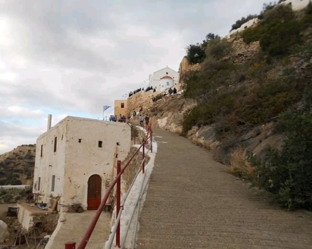
Not far from the coast, on the steep ground at the mouth of the gorge and reached by an asphalt road, lies the monastery of St Antony (Moni Agiou Antoniou Arvis), with a wide view of the sea. It was founded around 1880 by the priest-monk Artemios, in the world Konstantinos Nodarakis, a fighter in the Cretan risings of 1866 and 1878. At first he settled at the exit of the gorge, on the very spot where the ancient sanctuary of Zeus is thought to have stood, among its ruins. Marshy ground and heavy damp, however, compelled him to move the monastery to the eastern edge of the slope, where the first cells and the church were built. The older monastery church, lower down, fell into decay with time; in 1905 a new katholikon was built beside the monks’ cells on the hillside. The community drew its water from an old spring, from which it was raised with a simple lifting device.
Prosperity and decline
The monastery had its heyday at the beginning of the 20th century. Around 1900 seventeen monks lived here in strict community under the abbot Ananias Chordakis; by 1911 there were twenty-four, some of them from the monastery of Koudoumas on the south coast of the Asterousia Mountains. The house owned land in the valley and was closely bound up with the farming of Arvi; besides a bakehouse, stables and storerooms it even had a boat of its own, by which contact was kept up with the monasteries of Sinai and Egypt. Later the number of monks declined. After the war the monastery lay almost deserted; only around 1960 did brothers come again from Koudoumas, in the persons of the priest-monks Hierotheos Kostomanolakis and Timotheos Karpouzakis, and from 1977 to 1992 the elder Ioannikios Androulakis built new cells and outbuildings.
Remembering the monastery and the war
Of the monastic complex there remain today a few half-ruined buildings, among them the shells of the monks’ cells, and two churches dedicated to St Antony, one very old and one fairly new. The names of the abbots and monks live on in the church memory of Arvi. Among them is the priest-monk Kyrillos Synadinakis, the last to hold out in the monastery: he was maltreated and shot by German occupation troops on 14 September 1943, as their units moved through Viannos and along the south coast in the course of their reprisal operation; with him, according to local tradition, died a labourer of the monastery. The Germans had declared the district a prohibited zone, and the other monks had withdrawn to another monastery; the abbot’s house and the wine cellar went up in flames. The patronal feast is kept on 17 January, the day of St Antony. For some years a committee, together with the diocese of Arkalochori, Kastelli and Viannos, has been working to restore the buildings.
How to explore Arvi
Arvi is best taken in as a single landscape of nature and history: first the lagoon and the river mouth, then a look into the rocky cleft of the gorge, and after that the way to the church of the Panagia and up to the monastery of St Antony. In this way the connections between sea, farming, monastic life and the memory of the wartime events become clear. The round can be done comfortably in a couple of hours, on foot from the seafront. Those with time to spare stay until evening, when the villagers sit in the tavernas by the water and the bananas of the valley are sold at stalls along the road.