Lyttos: the ancient city above the Pediada (not to be confused with Lato)
The most complete guide to Crete: 221 places on the map, 23 routes and 49 articles — with photos, videos and the story behind every place. No sign-up, no trackers.
Routes drawn along real roads
Weather at every stop
Full-text search
“Near me” by geolocation
Create your own printable itinerary
Satellite, terrain, dark mode
Works offline
⌕
Searches 1.7 million characters of descriptions, not just names
—places
4regions
—routes
—with video
Search results
—
Interactive map
Find what is near you
Filters narrow the map and the list at once. Zoom out and pins group together.
Region
Category
Фильтры карты
Landmarks
Featured places
RegionCategory
Routes
Ready-made day trips
Individual places
Articles about landmarks
Ancient Lyttos (Lyktos) – not Lato
Lyttos, in the older form of the name Lyktos, crowned a long ridge on the western edge of the Dikti Mountains, a good 600 metres above the sea, above the present village of Xidas, which has officially resumed the name Lyttos. From Kastelli Pediados it is about four kilometres. Anyone who comes up understands the choice of site at once: the view takes in the whole Pediada as far as the Sea of Crete, and the way to the Lasithi Plateau passed at the city’s feet. The name is far older than the Dorian city – it occurs as ru-ki-to on Linear B tablets and in an Egyptian list of Aegean places from the mortuary temple of Amenhotep III. In the Classical period the territory of the Lyttians stretched from coast to coast – Strabo puts the city 80 stades from the Libyan Sea – and their harbour on the north coast was Chersonesos.
Zeus, Sparta and the war with Knossos
Lyttos is named by Homer, Strabo and other ancient authors; in the Iliad it is among the Cretan cities whose warriors sail with Idomeneus for Troy. Mythology linked the city with the birth of Zeus and with Mount Dikte: according to Hesiod’s Theogony, Rhea brought her child to Lyktos to hide him from Kronos in a cave on Mount Aigaion. Such tales belong to the religious memory of Crete; they are not archaeological evidence for events. To the Greeks Lyttos was, moreover, a daughter city of Sparta – Aristotle calls its people Spartan colonists – and a place of especially archaic Dorian institutions; Polybius calls it the oldest city on the island and the mother of its bravest men.
With Knossos the city lived in permanent enmity. Around 343 BC the Knossians took Lyttos with the help of Phocian mercenaries under Phalaikos, but the Spartan king Archidamos III drove the occupiers out. The war at the end of the 3rd century BC, which has gone down in history as the Lyttian War, had graver consequences: when, about 220 BC, the Lyttians had taken the field with their whole levy, the Knossians fell upon the undefended city, carried off the women and children and burnt everything to the ground. The returning men, Polybius says, found only ruins and sought refuge at Lappa. Lyttos thus suffered heavy defeats more than once, but recovered its independence with Spartan support – and, later, with land made over to it by Gortyn – and was rebuilt. In the Roman period – the city had been reduced in 67 BC by Quintus Caecilius Metellus – it kept its civic institutions and its coinage and enjoyed a late flowering, to which numerous honorary inscriptions for the emperors Trajan and Hadrian bear witness.
What there is to see
Water was scarce on the ridge. The supply was secured by the spring of Kournia above the village of Krasi, at more than 600 metres on the flank of the Lasithi mountains, and by a stone aqueduct of the age of Augustus that carried the water some 22 kilometres along the hillside in a channel barely forty centimetres wide. An impressive stretch of the Roman line, a mighty wall several dozen metres long, up to ten metres high and more than two metres thick at the base, survives near Kastamonitsa; pierced stone pipe-blocks found close by suggest that the water crossed the last dip under pressure. On the coins of Lyttos appear the eagle in flight and the head of Zeus with the legend of the Lyttians, on the older issues also a boar’s head. Ancient and modern authors mention a large theatre – the Venetian Onorio Belli drew it in the 16th century as the largest on the island – but its exact position is no longer certain.
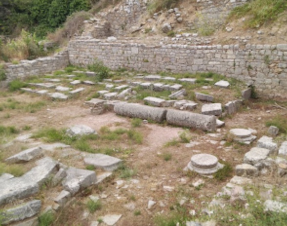
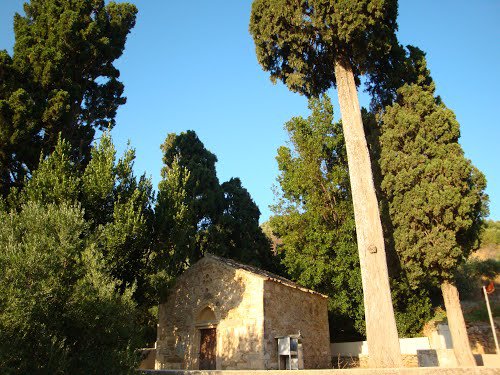
So far only a small part of the extensive city area – two citadels, a circuit wall and several cemeteries – has been excavated. Arthur Evans toyed with the idea of digging here and never did; in the early 1980s Giorgos Rethemiotakis uncovered a Roman council house with stone benches, and since 2021 a new programme directed by Angelos Chaniotis and Antonis Kotsonas has brought further public buildings and inscriptions to light, together with a headless marble statue of Hadrian found in the very first season. On the crest of the site one sees lines of walls, scattered architectural members, the stumps of old windmills and two Byzantine churches: Agios Georgios, in whose walls ancient blocks and inscribed stones are embedded, and the church of the Holy Cross (Timios Stavros), which stands over the remains of an early Christian basilica. Many finds – statues, inscriptions, reliefs – are kept in the Archaeological Museum of Heraklion.
The site is freely accessible and reached by a narrow road from Xidas. There is neither shade nor water at the top, but on clear days there is one of the widest views in central Crete – at its best in spring, when anemones and orchids flower among the stones.