The most complete guide to Crete: 221 places on the map, 23 routes and 49 articles — with photos, videos and the story behind every place. No sign-up, no trackers.
Routes drawn along real roads
Weather at every stop
Full-text search
“Near me” by geolocation
Create your own printable itinerary
Satellite, terrain, dark mode
Works offline
⌕
Searches 1.7 million characters of descriptions, not just names
—places
4regions
—routes
—with video
Search results
—
Interactive map
Find what is near you
Filters narrow the map and the list at once. Zoom out and pins group together.
Region
Category
Фильтры карты
Landmarks
Featured places
RegionCategory
Routes
Ready-made day trips
Individual places
Articles about landmarks
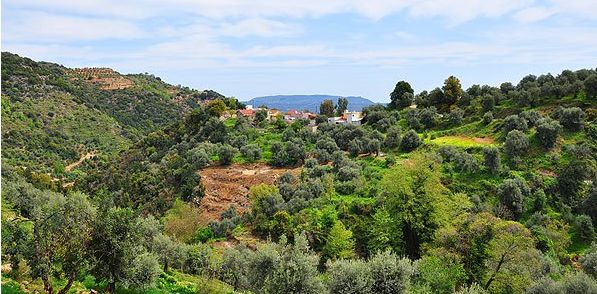
The villages of Keramia on the slopes of the White Mountains
The villages of Keramia form a cluster of settlements on the northern slopes of the mountains Orino, Mavri and Psara, east of the Therisso Gorge. The district forms a triangle between Kambi, Therisso and Malaxa. Hillsides alternate here with green gardens, and narrow roads link small villages, chapels, caves and old farmhouses. In the historical sources the landscape is called Keramia (Κεραμειά); today the villages often count no more than a few dozen permanent inhabitants, who live by olives, wine, stock-rearing and bee-keeping. Although the area seems close to Chania, it is reached only by narrow, winding hill roads, which is why it has remained little developed and seldom visited; the whole municipal unit, which since the local-government reform of 2011 has belonged to the municipality of Chania, had just 738 inhabitants at the census of 2021, spread over almost ninety square kilometres.
The name and the potter’s craft
Local tradition connects the name Keramia with the colour of the soil and with the clay suitable for making pottery. Some local histories derive the name instead from a mountain called Keramon, others think of an ancient town named Kerameia, and a popular reading even finds in it an invocation of the Mother of God; the origin of the place name cannot, therefore, be regarded as settled. The reference to the potter’s craft nevertheless suits the character of the district well, for here it was the natural raw materials that shaped the economic life of the settlements. It is telling that the excavator of the cave of Platyvola took the Minoan vessels found there, on account of their quantity and quality, to be the products of a local workshop.
The historical landscape included Panagia, Achlades, Loulos, Gerolakkos, Alitrouvari, Agios Georgios, Drakona, Platyvola and further small settlements, with Malaxa, Katochori and Kontopoula on its fringes; Gerolakkos was the seat of the former municipality. Some of these villages are today almost deserted – Platyvola, which lies at 448 metres, fell from 157 inhabitants in 1981 to 30 a decade later – yet their paths preserve the old structure of the upland farming landscape. Keramia also had its share in the history of the island: in 1645 two local captains hurried with their men to help the Venetians in the defence of Chania, and at Loulos on 14 June 1821 one of the first engagements of the rising in western Crete took place.
Gerolakkos and the church of St John
In Gerolakkos stands the Byzantine church of St John (Agios Ioannis). It is visited not only as a place of worship, where the liturgy is still celebrated, but also as a monument of local building: the small churches of Keramia were as a rule put up in rubble masonry, with a simple plan and with wall paintings designed for the confined space of a village church, where the painter had to fit the whole cycle of feasts and saints on to a few square metres of vault and wall.
Platyvola and the cave of Platyvola
Near the village of Platyvola lies the cave of the same name, counted among the sacred caves of Minoan Crete. The caves of Keramia belong to the limestone relief of the White Mountains: water slowly dissolves the rock and leaves hollows and small underground passages. Such places should be approached with caution, for most of them are not laid out for visitors, and a torch, sure footing and a companion are the minimum for anyone who goes beyond the entrance.
The usual last stop on the route is Drakona, less than 25 kilometres from Chania and 510 metres above the sea, a village of some 220 to 250 people at the censuses of the 1980s and 1990s. From here there are views over gorges and wooded slopes; the drive rewards those who want to know not a single sight but a whole upland with its villages, springs and paths. Tradition explains the village’s name by an enormous, unusually hard boulder on the slope opposite the village square, the “dragon stone”, which according to legend giants hurled here while throwing rocks at one another. The church of St George bears over its entrance the year of its renewal, 1833, and has a gilded carved iconostasis. In winter only fifty or sixty people live in Drakona, yet the village produces around 200 tonnes of olive oil a year and at least 30 tonnes of honey from thyme, oregano and marjoram, to which a honey festival of its own is devoted. High above the village, at about 1,000 metres, stands the chapel of St Modestos (Agios Modestos) at Psychro Pigadi, reached by old cobbled paths past an abandoned metochi, ancient cisterns and terraced fields; the local mountaineering club walks there in about seven hours and returns by a gorge that once carried traffic to Anopolis in Sfakia.
Nerokourou and the Middle Minoan heritage
On the way back to Chania one can turn off via Mournies and the national road to Nerokourou, a few kilometres south-east of the city in a fertile farming zone. The village is known not only for its traditional architecture but also for an archaeological site of the Minoan period. The Greek-Italian excavations of 1977 to 1982, directed by Giannis Tzedakis and Antonio Sacconi and published in Italian in 1989, uncovered a settlement founded at the end of the Middle Minoan period; it is one of the very few examples of Neopalatial architecture in western Crete.
House I shows the features of a Minoan “villa” on the palatial model: paved floors, a polythyron – a wall dissolved into a row of doors – and an upper storey. The building has a Minoan hall with porch, antechamber and main room, the antechamber being unusually as large as the hall itself, and the porch, at first open, was later closed to serve as a light well. On the evidence of architecture and pottery the complex, with its successive building phases, is placed around 1600 BC, in the transition from Middle Minoan III to Late Minoan I, and it came to an end in the destructions of Late Minoan IB. Sadly, about two-thirds of the house, its northern and western parts, were destroyed by a bulldozer in three days before the excavation could save them. To the east stood a square building with a waterproof floor and a small cistern, some 300 metres away a second building with storerooms, in which seven rope-decorated storage jars were found still in place, and on the north-west edge of the dig a stretch of paved road; in other layers Early Minoan pottery came to light from a pit, together with building remains of the Late Neolithic, which here means the centuries around 3500 to 3000 BC. The finds – pottery, stone tools, a tablet in Linear A, implements for bronze-working and a fragment of a potter’s wheel – point to a house in which food was processed and crafts practised, comparable to the town houses of Knossos.
In the wider surroundings of Nerokourou monuments of the Classical, Hellenistic, Roman and early Christian periods have been recorded. Thus the drive through the villages of Keramia to Nerokourou joins a mountain route with the archaeology of several millennia, from the Neolithic farmers of the plain to the Byzantine chapels of the hills.
How the route runs
One can begin the drive from Mournies or from Chania, climb by way of Panagia and Achlades to Loulos and Gerolakkos, and then go on to Platyvola and Drakona, the last two villages lying only a kilometre and a half apart. The roads are narrow and in places mountainous, and the keys of the chapels are often held in the village. In the kafenia and tavernas of the villages simple dishes of the Cretan kitchen are served from local produce; in Drakona one taverna enjoys a wide reputation, cooking still entirely without electricity over a wood fire, and another, at Psychro Pigadi, sits high above the village with a view over the whole of Chania.