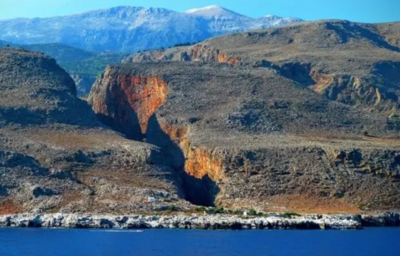
Samaria Gorge: across the White Mountains from Chania to the Libyan Sea
The most complete guide to Crete: 221 places on the map, 23 routes and 49 articles — with photos, videos and the story behind every place. No sign-up, no trackers.
Routes drawn along real roads
Weather at every stop
Full-text search
“Near me” by geolocation
Create your own printable itinerary
Satellite, terrain, dark mode
Works offline
⌕
Searches 1.7 million characters of descriptions, not just names
—places
4regions
—routes
—with video
Search results
—
Interactive map
Find what is near you
Filters narrow the map and the list at once. Zoom out and pins group together.
Region
Category
Фильтры карты
Landmarks
Featured places
RegionCategory
Routes
Ready-made day trips
Individual places
Articles about landmarks
This route crosses the crest of the White Mountains and descends through the Samaria Gorge to the Libyan Sea, to Agia Roumeli and its beaches. It links the northern approach by way of Omalos with the south coast of Crete and leads through mountain villages and shepherds’ country, through forests and past springs, along old paths and to monuments of both ancient and Byzantine history. Scarcely another day’s journey on the island passes through so many landscapes in so short a distance: orange groves, high pastures, cypress forest, bare rock and a beach of pebbles.
From Chania to the Samaria Gorge
The start of the route
Leave Chania heading south and follow the road through the green valley of the Keritis, known for its orange and lemon orchards. After about fifteen kilometres, turn off at a fork for Fournes and Lakki. From here the road climbs in a long series of hairpins up the northern slopes of the White Mountains. Before going further, bear in mind that the route ends at the sea, in Agia Roumeli: there is no road back from there, and the journey home begins by boat. Anyone intending to walk the gorge therefore does best to take the scheduled bus from Chania to Xyloskalo – a good forty kilometres – and leave the car behind.
Lakki
Lakki (Λάκκοι; officially Lakkoi, though road signs and maps generally write Lakki) is a village steeped in history on the northern slopes of the White Mountains, about 24 kilometres from Chania and some 530 metres above sea level. Its name – “the hollows” – is explained by the natural dips in the ground in which its several quarters lie; another reading has it recall the watering holes the first settlers dug for their animals. Tradition says those settlers came from Sfakia. Its record of defiance is long: a chieftain of Lakki named Pentachtenis took part in a revolt against Venice as early as 1263, and in 1570 a certain George Mousouris served as secretary-general of the rebel forces. Under Venetians and Ottomans alike the mountain village was a refuge for Cretans who had joined the risings; the Turks accordingly ringed it with a chain of watchtowers, the remains of which still stand on the heights. During the War of Independence an Ottoman army of 5,000 men under Latif Pasha was beaten here, but in August 1822, after heavy fighting, the Ottoman forces destroyed Lakki and neighbouring Therisso. The inhabitants themselves, it is told, set fire to their houses and fields then, as they did again in the rising of 1866, so as to leave nothing to the enemy; in that later struggle a woman of the village, Katerina Stamataki, won distinction as a fighter. The people of Lakki also played their part in the national liberation movements of the 19th and 20th centuries: in 1858 delegates from several provinces gathered here to protest against the burden of taxation, and the village’s best-known son, Hatzimichalis Giannaris (1833–1916), led the insurgents of the province of Kydonia over three decades. In the Battle of Crete in May 1941, 485 men and women of the village resisted the invaders and 68 lost their lives. Once home to some 2,000 people, Lakki counted only 219 at the census of 2021. The main church of Agios Antonios dates from 1890; in the old quarter of Papadiana stands the small and venerable church of St George.
The natural world of the White Mountains
Nature here is almost untouched: pines, cypresses, oaks and scrub cover the slopes, and countless caves are hidden in the sheer walls. The massif of the Lefka Ori (Λευκά Όρη) owes its name to its pale limestone summits and to the winter snow; about twenty peaks rise above the 2,000-metre mark, the highest of them, Pachnes, reaching 2,453 metres, which makes it the second-highest mountain in Crete. In summer the snow lingers only at the greatest heights and in shady sinkholes – a sharp contrast between the hot south coast and the cool high mountains. The central and southern part of the range, at around 1,800 metres, is a bare upland often likened to a lunar landscape and described as a high desert. The rock – limestone ranging from light grey to bluish or almost black, with marble and dolomite – is riddled by water like a sponge: rain and meltwater seep away, feed underground rivers and come to light again only far below as powerful springs. The same water has cut some fifty gorges into the flanks of the massif, of which Samaria is merely the most celebrated.
Omalos
The road climbs to the plateau of Omalos (Ομαλός), at about 1,080 metres and 38 kilometres south of Chania. It is an enclosed mountain basin ringed by peaks, lying where three districts meet – the Chania side, Sfakia and eastern Selino; its area is given as between 15 and 25 square kilometres, depending on how much of the rim is included. In spring crocuses, wild tulips and other flowers spread across the meadows; in winter the plain lies under snow, and during the thaw a shallow lake forms for a short while in the hollows. In the past the people of Lakki grew cereals and potatoes up here – the cool climate and fertile soil also suit apples – and kept their mitata, the shepherds’ stone-built cheese dairies; flocks are still brought up to the pastures for the season. Today there is a small settlement on the edge of the plain with tavernas, an information office and rooms to let; camping is not allowed on the plateau. Besides the road from Lakki, a second approach comes in from the west off the Chania–Sougia road, and old stone mule tracks lead across to the Agia Irini Gorge.
Omalos, too, was a retreat of the insurgents. Throughout the Turkish period the Ottoman troops managed only rarely, and never for long, to gain a foothold here, and the famous song of the rebels – “When will the sky be clear of cloud, when will it be February …” – mentions the plateau by name. On its northern edge stand the tower and the tomb of Hatzimichalis Giannaris – he died in Chania but wished to be buried at Omalos – and the chapel of Agios Panteleimon, which he had built in fulfilment of a vow after his escape from the Firka fortress in Chania and which was consecrated in 1862.
The Tzani Cave
The waters of the plateau drain towards the enormous Tzani Cave, also called Spilia Tzani or simply Chonos, “the funnel”. Its mouth lies on the northern edge of the plain, beside the road that descends towards Chania, about two kilometres from the start of the path to Samaria. According to a local tradition, the flute of a shepherd can be heard in its depths, his tunes enchanting the nymphs. The name is traced to the rebel captain Markos Tzanis, the terror of the conquerors; another, legendary version tells of a brave warrior who went down into the cave and never returned.
In the 1960s French speleologists, together with men from Chania, explored the system: the part they traversed reached a length of about 2,500 metres and a depth of some 240 metres without any end being reached. In essence it is a vast underground gorge, a ravine that happens to have a roof, and according to an old belief the water that vanishes here comes to light again only at the springs of Agia on the plain of Chania. The Tzani Cave is thus not only a natural monument but also a place where the history of the earth, the memory of the insurgents and the legends of the shepherds meet. The interior is reserved for experienced and properly equipped cavers.
The Samaria Gorge
The gorge (Φαράγγι της Σαμαριάς) begins at Xyloskalo on the southern edge of Omalos, at around 1,200 metres, and opens into the Libyan Sea at Agia Roumeli. It was cut by a small river running between the main mass of the White Mountains and Mount Volakias. The whole walk measures about 16 kilometres: roughly 13 kilometres lead along the stream bed and the path of the national park, and a further three along a surfaced track to the coast. In 1962 the gorge and the surrounding slopes were declared the National Park of the White Mountains, above all to protect the rare kri-kri; the Council of Europe awarded the park its European Diploma in 1979, and UNESCO has listed it as a biosphere reserve since 1981. The path is open only in the warm season, as a rule from the beginning of May to the end of October; in winter rushing water and rockfalls make the gorge impassable, and the wooden bridges are dismantled.
From Xyloskalo to Agia Roumeli
Xyloskalo
The descent begins at 1,227 metres. The name Xyloskalo (Ξυλόσκαλο), “wooden stair”, recalls the makeshift ladder of cypress trunks by which the inhabitants once negotiated the topmost steep step. From here the view opens on to the White Mountains and the rugged rock mass of Gigilos, which reaches a good 2,000 metres and on which legend places the throne of Zeus. The upper part of the way runs over wooden walkways and steps with handrails; in the first twenty minutes one loses about 200 metres of height. Springs along the route have been channelled so that drinking water can be drawn; all the same, it is wise to ask about their condition before setting out and to carry a supply of one’s own.
In a small clearing among old pines and mighty cypresses – the largest in the whole gorge – stands the church of Agios Nikolaos. Its position on the old path is a reminder that Samaria was never an empty wilderness: shepherds, woodcutters, pilgrims and the people of the mountain villages passed through here, and it is thought that a deity was already worshipped on this spot in antiquity. The cypress wood of the White Mountains was much sought after; it was used in shipbuilding and, it is supposed, by the builders of the Minoan palaces before that.
Samaria
Further down, the path reaches a wooden bridge and the former village of Samaria, which lies roughly halfway along. Until 1962 a few Sfakian families lived here from stock-rearing and timber; when the gorge became a national park the inhabitants were resettled, the last of them leaving in that year. Their houses now serve the park wardens and as a resting place with a first-aid station. The churches of Christos and Osia Maria survive. The second is dated to 1379 and is decorated with frescoes of the Palaiologan period, that last flowering of Byzantine art. The icons of the two churches are today kept in monastic collections on the Holy Mountain of Athos. In May 1941 Greek history, too, took its course through the gorge: King George II and his government fled before the German troops by way of Omalos and Samaria to Agia Roumeli, where a British destroyer took them off to Egypt.
Sideroportes – the “Iron Gates”
From Samaria onwards the path drops between rock walls 300 to 400 metres high and crosses the stream several times. At the narrowest point, where the walls stand only three to four metres apart, the cliffs soar to almost 500 metres; their reddish-brown colouring recalls rusty iron and explains the name. The rocks close in so tightly that only a narrow strip of sky remains overhead.
Beyond the Iron Gates the gorge gradually widens. The path reaches a clearing with an old olive tree, surrounded by oaks, pines and cypresses, then becomes gentler and leads to the southern exit, where the entrance ticket is shown a second time – this is how the park authority makes sure that nobody is left in the gorge at nightfall. The old village of Agia Roumeli lay above the present shore; the Turks, unable to force their way up the gorge in 1867, burnt it down, and after devastating floods of the stream in the 1950s, and finally with the creation of the national park in 1962, the inhabitants moved between one and two and a half kilometres further down to the sea. In the surrounding area stand Byzantine churches, one of which has a mosaic floor, and on the heights the remains of Ottoman guard forts from the time of the risings.
Agia Roumeli
Agia Roumeli (Αγία Ρουμέλη) is a small settlement by the sea at the southern exit of the Samaria Gorge – two parallel streets along the water and, at the last census, 78 permanent residents. By land its chief link with the north of Crete is the footpath through the gorge; regular traffic is provided by the boats to and from Chora Sfakion, Paleochora and Sougia. The present village has grown up beside ancient Tarra, an independent city that came to prominence in Greek and Roman times as a religious centre. In the 3rd and 2nd centuries BC it struck coins bearing the head of the Cretan wild goat, an arrow and a bee – the goat and the bee emblems of stock-rearing and bee-keeping – in a monetary union with its neighbours Elyros, Hyrtakina and Lissos, and it belonged to the league of the mountain cities, the Oreioi; like other Cretan cities it concluded a treaty with Eumenes II of Pergamon. Tarra was closely bound up with the cult of Apollo Tarraios: according to the myth, the god sought purification here, at the hands of the priest Carmanor, after he had slain the Python at Delphi. Carmanor’s son Chrysothemis was remembered as a poet and victor at the Pythian Games, and a later native, Lucillus of Tarra, wrote a commentary on Apollonius of Rhodes. The Florentine traveller Cristoforo Buondelmonti, who came this way in 1415, copied an inscription instructing the worshipper to take off his shoes, cover his head and enter; in the 19th century Robert Pashley was the first modern scholar to identify and examine the site. A stone stele from Tarra carved with double axes is displayed in the Archaeological Museum of Chania.
The church of the Panagia stands on the site of the ancient sanctuary, amid the remains of an early Christian basilica whose floor is still attested by mosaics. East of the village, a good hour’s walk along the beach, stands the Byzantine church of Agios Pavlos; tradition connects it with the Apostle Paul, who is said to have come ashore and baptised here. The ruins of the Turkish fortifications keep watch over the mouth of the gorge – the most conspicuous is the castle on the hill to the west of the village – and above lie the traces of the old settlement, which was moved closer to the sea after the destructive floods. In Venetian and Ottoman times the timber of the gorge was sawn at Agia Roumeli and built into ships; the place was also known in the Middle Ages for its glass workshops. Today the village lives from fishing, sheep-farming, bee-keeping and the walkers who end their passage through Samaria here, cool their feet in the Libyan Sea and wait for the boat. Botanists have their own reason to come: on nearby Fournoti beach a micro-reserve of about six and a half hectares protects the rare shrub Hypericum aciferum, of which little more than a hundred plants are known.
Practical advice
The full walk generally takes five to seven hours, depending on pace, weather and physical condition. Practised hill walkers cover the main stretch more quickly, but haste is hard on the knees and, on the stony sections, increases the risk of a false step.
Along the way there are eight rest areas – among them Neroutsiko, Riza Sykias, Agios Nikolaos and Perdika – where one can draw breath, refill water bottles and use the lavatories. Nothing is sold in the gorge; bring light provisions with you. The path runs over uneven ground, and sturdy footwear is indispensable even on a cool day. Fires, camping or staying overnight, bathing in the stream and picking plants are forbidden in the park.
Admission begins early in the morning. Entrance fee and opening times change with the season; before setting out, check the official information of the national park and look out for closures on account of heat, rain, rockfall or fire risk. In the summer months an early start helps to avoid both the heat and the crowds.
The classic route from Xyloskalo to Agia Roumeli is about 16 kilometres long. After leaving the gorge, there remain some three kilometres on the track to the sea. From Agia Roumeli one returns by ferry or excursion boat, usually in the late afternoon; the crossing to Chora Sfakion takes about an hour, and from there buses run to Chania. The timetable depends on season and weather, so the return journey should be planned in advance.