The road from Sitia to Zakros crosses the north-eastern corner of Crete, a bare, wind-scoured country that proves far more varied than it looks from a distance. It strings together the palm grove of Vai, Toplou Monastery, ancient Itanos, the district around Palekastro (Palaikastro) and the Minoan palace of Zakros, and in doing so it unfolds, stage by stage, the coastal landscape, the history of the Cretan city-states and the religious inheritance of the island. Much of the land along the first half of the way, the palm grove included, has historically belonged to Toplou, which gives the journey a certain unity.
Two things mark this corner of the island: the palm grove of Vai lies within a strictly protected natural area, and ancient Itanos, at Erimoupoli, was a port that lived by trading in purple dye, glass, sponges and fish. The palace of Kato Zakros, covering about 8,000 square metres and comprising several hundred rooms, ranks as one of the four great Minoan palace centres of Crete, alongside Knossos, Phaistos and Malia. It was never plundered after its destruction, and it has yielded the second-largest body of Linear A documents found anywhere.
The first great sight is Vai, with its unique wood of date palms. It lies like an oasis at the edge of the island: white sand, turquoise water and the dry rustle of palm fronds in the wind. The trees fill a shallow valley running back from the sea at right angles to the beach, barely above sea level.
Further south, Zakros awaits with its celebrated Minoan palace. The ruins carry the visitor back to a very remote age and give a clear picture of the daily life, economy and beliefs of the Minoans, who maintained here one of the most important harbours of the Aegean, with proven links to Egypt and the East.
Toplou Monastery lends the route its moment of quiet and reflection. Built in the Venetian period and ringed by its own vineyards and olive groves, it is known for its icons and for a treasury of ecclesiastical art, and from the outside, behind its high square walls, it looks more like a small fortress than a house of prayer.
The drive therefore opens up not only the historical and cultural heritage of Crete but also the splendour of its natural scenery. Those who take their time will see how much variety the island packs into a small space. Allow a full day for the whole route, including the visits and a pause for a swim; by road, Sitia and Kato Zakros are about 45 kilometres apart.
Agia Fotia
We leave Sitia heading east, pass the village of Petras – now a popular holiday spot, on whose hill archaeologists have uncovered a Minoan palatial centre – and after about five kilometres reach Agia Fotia (Αγία Φωτιά, “Holy Fire”). The place takes its name from a pretty little church standing in a pine wood well supplied with springs. For many years Agia Fotia was an almost idyllic backwater, loved above all by young people who spent the summer here under canvas. Wild camping is now forbidden, but the young still come to the village’s small beaches and have found their own easy-going way of passing the days.
On the shore below the village is the cave of Koufoto Spileo, where traces of very early human presence have been found; the caves hereabouts have produced Neolithic as well as later prehistoric material. Close by, in 1971, archaeologists came upon the largest prehistoric cemetery in Crete and one of the largest in the whole of Greece. It lies at the spot called Glyphada, only about 150 metres from the hilltop building described below. The excavations, associated with the name of the archaeologist Kostis Davaras, brought to light 252 tombs, dated to the first half of the 3rd millennium BC, that is, to the Early Minoan period. The chamber tombs, cut into the soft rock, have roomy, oval burial chambers. They contained some 1,800 vessels of clay and copper in the most varied shapes, together with household objects of stone and copper, numerous obsidian blades and objects of cult.
The pottery, still shaped without the potter’s wheel, shows close ties with central Crete but above all a strong influence from the Cyclades – many of the grave goods are purely Cycladic in origin – which is why scholars speak here of a mixed Cretan-Cycladic culture, and some have even thought of a colony of islanders. Many of the finds are now displayed in the Archaeological Museum of Agios Nikolaos, where a whole room is devoted to them; others are in the Archaeological Museum of Sitia.
On the hill of Koufota a complex of 37 rooms was discovered, grouped around a rectangular court – an early forerunner of the vast palace of Knossos. The building, which belongs to the Old Palace period, was protected by an enclosure wall strengthened with rounded buttresses, and from this small “palace” archaeologists conclude that armed conflict was already a fact of life in Crete at an early stage of Minoan history. Among the village’s other sights is an old windmill of the Cretan type, protected as a cultural monument.
Continue along the coast road and you meet hardly another settlement. In the Middle Ages this shore was a lair for pirates, and the local people preferred to settle higher up on the mountain slopes, where they were safer from raids from the sea. Only in recent times, with the coming of tourism, have they moved back down towards the coast.
Toplou Monastery
Toplou Monastery rises like a fortress from the barren, stony upland some 18 kilometres east of Sitia and six kilometres north of Palekastro, at the base of the promontory of Itanos; it has stood guard over eastern Crete since the 14th century. Its original name is Moni Panagias Akrotirianis (Παναγία Ακρωτηριανή), “Our Lady of the Cape”, because it lies at the far eastern end of the island. Corsairs sacked it in 1498, and in 1538 Barbarossa raided it, burning the crops and carrying people off as slaves; after such attacks it was turned into a defensible stronghold behind square walls ten metres high. Those walls, pierced with loopholes and armed even with a cannon, gave it the name it bears today: the Turkish word “top” means cannon, and Toplou, attested in Ottoman documents from 1673, is one of the few places in Crete to have kept a Turkish name.
A severe earthquake in 1612 badly damaged the monastery. The learned abbot Gavriil Pantogalos had it rebuilt with the support of the Venetian authorities – in March 1613 the Republic voted 200 ducats for the work – and the 17th century became its golden age, when it owned extensive estates in eastern Crete and even property in Chandax, the present Heraklion. The Venetian families of Cornaro and Mezzi were regarded as its patrons and protectors. The prosperity did not outlast the Ottoman conquest: Toplou surrendered in 1646 and lay deserted for a long time, until in 1704 it was granted the protected status of a stauropegial house and monks returned.
The scale of the place is impressive. The main building covers about 800 square metres and has three storeys enclosing a small inner court paved with sea pebbles. On the ground floor were monks’ cells and storerooms; on the first floor are the refectory – its walls now painted with modern frescoes by Manolis Betinakis – and the guest rooms, in which pilgrims may stay without charge. Roofed stone galleries link the twenty or so rooms, and on the top floor are the monks’ cells and the abbot’s reception room. The gate is reached through a vaulted passage; above it opens the so-called foniaria, an aperture through which attackers were once doused with boiling oil. The two-storey bell tower in Renaissance style, dated 1558, served also as a watchtower and commands a magnificent view over the surrounding country.
The handsome two-aisled monastery church is dedicated to the Nativity of the Virgin and to St John the Theologian. In the older, northern part, which now forms the sanctuary, wall paintings of the second half of the 14th century survive, with scenes from the lives of Christ and the Virgin; they are the oldest datable element of the whole complex. Stone inscriptions are let into the façade, among them verses in honour of Abbot Pantogalos and a famous document of antiquity: the arbitration of the city of Magnesia on the Maeander of 112 BC, which, on the instructions of the Roman Senate, settled the dispute between Itanos and Hierapytna over the sanctuary of Dictaean Zeus and the island of Leuke (today’s Koufonisi) in favour of Itanos.
Beside the monastery stands a traditional stone windmill. Toplou played an active part in the risings against Ottoman rule and paid a high price for it. In June 1821, in the year the Greek War of Independence broke out, twelve monks and about as many laymen were killed at the entrance; they are commemorated as new martyrs every year on 26 June, and the monastery stood empty again until 1828. During the revolt of 1866–1869, in which the buildings once more suffered badly, Abbot Meletios Michelidakis sat on the revolutionary committee. In the Second World War the monks hid a wireless set that kept contact with Allied headquarters in Cairo; the German occupiers arrested Abbot Gennadios Sylignakis and two monks, and the abbot and one of his brethren were executed.
The monastery museum, entered just inside the main gate, holds a wealth of precious exhibits: icons, liturgical vessels, vestments, manuscripts and printed books from the 15th to the 19th century, and a notable collection of engravings, together with some twenty portraits by the painter Thomas Papadoperakis. One of the most important works is a 15th-century icon of Christ Pantokrator attributed to Andreas Ritzos. Most famous of all is the icon known as “Megas ei Kyrie” (Μέγας εἶ Κύριε, “Great art Thou, O Lord”), revered as miracle-working and painted by Ioannis Kornaros in 1770. It is considered a masterpiece of the late flowering of Cretan painting and translates into images the prayer of the Great Blessing of the Waters: hundreds of figures people some sixty separate scenes arranged about a central axis showing the Trinity, the Baptism of Christ, the Virgin enthroned and the Descent into Hell, and surrounded by the four elements, the signs of the zodiac and the months.
Today Toplou is also known for its farming. The monks cultivate vineyards and olive groves organically and produce wine, tsikoudia and olive oil that are exported well beyond Crete; a shop inside the gate sells them. Every year on 26 September the feast of the Repose of St John the Theologian is celebrated here with a liturgy, a procession and a fair, which draw large numbers of pilgrims and visitors.
Vai beach
Vai is an ideal place for a day by the sea. The broad sandy beach is very well equipped: sunbeds and parasols, showers, a café and a restaurant, water sports, a seabed that shelves very gently and crystal-clear water. The large wood of date palms behind the beach makes one feel one has strayed into the Garden of Eden. The name of the place, incidentally, comes from the Cretan word “vagia”, meaning palm.
The grove numbers about 5,000 trees, filling a valley nearly a kilometre long. The stand of palms itself covers only some 20 hectares; the whole protected zone around it takes in up to 2,000. Before 1957, when the monastery of Toplou – the historic owner of the land – grubbed up most of it for cultivation, the wood is said to have covered about 300 hectares. It is now a declared reserve, designated an “Aesthetic Forest” and part of the European Natura 2000 network, since it is the largest surviving natural stand in Europe of the rare Cretan date palm, Phoenix theophrasti.
The species was first described by the Greek naturalist Theophrastus, the “father of botany”, in the 3rd century BC, and it is he whom its scientific name commemorates – a name given only in 1967 by the botanist Werner Greuter; Pliny mentions the palm too. It grows up to 15 metres tall, usually with several slender stems, and carries stiff grey-green fronds two to three metres long; the small yellowish-brown dates, barely 1.5 centimetres in length, are too fibrous and acrid to be worth eating. Scientists believe that in antiquity it was widespread throughout Crete. Another natural date-palm wood is said to exist in the Canary Islands; botanically confirmed small populations of the Cretan date palm survive at a few other places in Crete – in the gorge of Preveli, at Souda near Plakias and at Agios Nikitas – on some Aegean islands and on the south-western coast of Asia Minor, notably the Datça and Bodrum peninsulas. Popular legend has it that Phoenicians or Arab pirates raised the palms from date stones they had thrown away, but the fact that this is a distinct species disposes of such charming tales.
In the early 1970s hippies driven out of Matala discovered the grove as a new refuge; their permanent camps did the wood such harm that by about 1980 it resembled a rubbish tip. Only then was it cleaned up, placed under protection in the mid-1980s and, in 1987, fenced off; a European restoration project followed between 1999 and 2002. Camping, open fires and entering the fenced areas are now prohibited. The beach at Vai becomes very crowded in the summer months and is at its best for those who arrive early in the morning.
For a quieter swim there is a sandy beach south of Vai, though it has no facilities and is set in rougher, wilder surroundings.
North of Vai there are three more sandy beaches. The finest of them lies below the ancient city of Itanos, which is described in detail in the next section. Another attractive beach goes by the name of Chochlakia.
Ancient Itanos
Only two kilometres from Vai, on the hills of Erimoupoli (Ερημούπολη, “deserted city”), lie the ruins of ancient Itanos. The exact date of its foundation is still unknown, but the site is thought to have been inhabited as early as Minoan times, and a field survey of the district has indeed recorded Minoan sites all around, including a substantial Late Minoan house in the valley of Vai itself; finds attest occupation from the Minoan to the Early Christian era. Herodotus, the first historian to mention the city, tells of a purple-fisher of Itanos named Korobios who showed the settlers from Thera the way to Libya, where they founded Cyrene.
Itanos enjoyed its greatest prosperity in the last centuries before Christ, thanks to a strong merchant fleet that linked it with the most diverse regions of the Mediterranean, above all the Near East. Its territory then stretched from Cape Samonion, at the north-eastern tip of Crete, to Cape Erythrai far to the south-east – about 130 square kilometres – and it struck its own coins, some of them showing a woman whose body ends in a fish’s tail. Purple (porphyra), a deep red dye obtained from sea snails, played a particular part in the city’s economy. It was used to colour cloth and was very highly prized. The city also exported glass, sponges and fish.
Besides trade, the sanctuary of Dictaean Zeus brought the city a considerable income, for rich votive offerings flowed into it. Around 160 BC Itanos was in danger of being conquered by its neighbours Praisos and Hierapytna (the modern Ierapetra), but managed to preserve its independence with the help of the Ptolemies of Egypt, whose protectorate it had become and who kept a permanent garrison in the city. After Hierapytna had destroyed Praisos about the middle of the 2nd century BC, Itanos was threatened once more; this time the intervention of Rome saved the situation, and in 112 BC the arbitration of Magnesia already mentioned, whose text can be read on the church wall at Toplou, secured the city its territory.
The city lived on until AD 795, when a devastating earthquake all but wiped it out. The final blow came in 824 with the Arab invasions. There are signs that the site was modestly inhabited once again in the Venetian period. Its identity was established in the 1880s, when Federico Halbherr, working for the Italian mission of Domenico Comparetti, recognised it from its inscriptions. The French archaeologist J. Demargne excavated the basilicas in 1899–1900, a team from the French School at Athens returned in 1950, and from the 1990s French archaeologists, later joined by Danish colleagues, have explored and surveyed the whole area.
Among the ruins of Itanos today are the remains of three Early Christian churches of the first centuries AD, among them a large basilica on the eastern acropolis; of the pagan city, temples of Athena, Zeus, Asklepios and Tyche are known. On the western acropolis rises a massive watchtower of dark stone blocks; between the two hills lie Hellenistic residential quarters, and to the north is the necropolis, which has produced many burials and inscriptions. Part of the ancient city is now under the sea. All this makes the place especially rewarding for anyone interested in history and archaeology, the more so since a visit can be combined with a swim at one of the beaches at the foot of the ruins.
After Itanos the route leads back to Vai and from there southwards towards Palekastro, where new discoveries await the traveller.
Palekastro and its beaches
Palekastro (Παλαίκαστρο, “old castle”) is a small, quiet resort of some 1,250 inhabitants who still live largely off olives, vines and fishing as well as from visitors. The castle of the name stood on Kastri, a promontory 65 metres high. Two fine beaches of sand and fine shingle with crystal-clear water invite a swim: Kouremenos and Chiona (see the video above). In the bay of Kouremenos a strong north-westerly blows almost constantly, which has made it widely known among windsurfers; good conditions for windsurfing are reported at Chiona too, and the fish tavernas on the shore serve the day’s catch. The very gently shelving seabed also makes both beaches attractive for families with children. Anyone wishing to gain an idea of how local people used to live and work should visit the Folklore Museum (Laografiko Mousio), which is most instructive.
About three kilometres from Palekastro, at the place called Roussolakkos near Chiona beach, a Minoan town has been excavated. Its extent has been put as high as 300 hectares, of which some 50,000 square metres of remains are to be seen today, and its architecture differs markedly from the labyrinthine complexes of Knossos, Phaistos and Malia. A straight main street runs through the town and is crossed by four side streets, which divide the area into ten rectangular blocks. The surviving house fronts speak of stately buildings and handsome architecture. Paved streets, a system of water supply and drainage, numerous splendidly painted amphorae found in the houses together with jewellery, and many clay tablets in Linear A testify to the high culture and the town-planning skill of its inhabitants.
The first excavations were conducted by the British School at Athens from 1902 to 1906 under Robert Carr Bosanquet, together with R. M. Dawkins; a farmer had turned up a set of Minoan moulds close to the village in October 1899. At the same time John L. Myres explored the peak sanctuary on nearby Petsofas, the hill just south of the town, where offering tables inscribed in Linear A have been found. Work was resumed in 1962–63 by L. H. Sackett and M. R. Popham and has continued since 1983. The plain was already settled around 2900 BC; around 1900 BC a large, regularly planned town arose with contacts reaching to Egypt and Asia Minor. Earthquakes, the ash of the Thera volcano and fires in the early 15th century BC dealt it heavy blows, but it recovered and was only gradually abandoned after a further earthquake around 1300 BC.
What the town was called in antiquity has not yet been established. Its people lived at the last on the neighbouring hill of Kastri and in the 12th century BC moved of their own accord up into the highlands, where they founded new settlements. The many finds from the excavations are in the museums of Heraklion, Chania and Agios Nikolaos, and in Sitia. World-famous is the “Palekastro Kouros”, a precious statuette of a young man, about 50 centimetres tall, carved from hippopotamus ivory, with sandals and belt of gold leaf, hair of grey-green serpentine and eyes of rock crystal, the parts held together with dowels of olive wood. It lay smashed and burnt in the debris of the destruction of c. 1450 BC and was recovered piece by piece between 1987 and 1990; it is thought to represent a youthful god, perhaps a very early form of Zeus, and is now in the Archaeological Museum of Sitia.
Of particular importance is a stone slab engraved with the text of a hymn to Dictaean Zeus. Four fragments of the limestone stele, inscribed on both faces, were found in May 1904; the slab is now in the Archaeological Museum of Heraklion. The inscription itself dates from Roman times, from the early 3rd century AD, but its text goes back to a considerably older poem, composed in the late 4th or early 3rd century BC. It was the first find to point directly to the worship of a deity at this spot, and it made it possible to locate here the famous sanctuary of Dictaean Zeus, which was in use from the 8th century BC to the 4th century AD. Nothing comparable has been found in the labyrinthine palace towns, and scholars have advanced various conjectures to account for it.
According to a widely held interpretation, incidentally, the hymn contains the oldest conservation rules in the world, such as the ban on felling trees in the wood that belonged to the temple of Zeus; anyone who broke it could expect severe punishment. In essence the whole text – six stanzas with a recurring refrain – is devoted to the preservation of peace and life in Crete: the god is called upon to make the herds and the fields fruitful, to bless the cities and the ships, and to uphold justice and peace.
Palekastro
Chiona beach
Kouremenos beach
Xerokambos beach
The Minoan town
The palace of Zakros and the Gorge of the Dead
The way down to Zakros is uncommonly picturesque: on one side lies the broad water of the bay, on the other rise the sheer rock walls of the Gorge of the Dead,
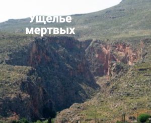
which owes its name to the many caves in which burials of pre-Minoan and Minoan date have been found; the Minoans laid their dead to rest in the rock niches of the steep walls.
The lushly green gorge, home to wild goats and falcons, offers walkers unforgettable views. The waymarked path, a section of the European long-distance route E4, begins near Ano Zakros, descends among plane trees, oleander, bay, fig and carob, and is not technically difficult; depending on where you start, reckon on two to three hours. It can be walked for almost the whole year, though with caution in winter. The hamlet of Kato Zakros sits snugly where the gorge opens to the sea, with a shingle bay and a handful of tavernas.
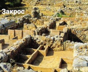
Here were found the ruins of the Minoan palace town of Zakros, which some take to have been a summer residence of King Minos, famed for his wisdom and justice. According to the myth, Minos met Zeus every nine years and received from him laws engraved on tablets of bronze. So just were these laws that Minos was acknowledged as king of all Crete.
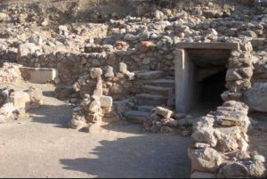
The first excavations were undertaken in 1901 by the Englishman David G. Hogarth for the British School at Athens; he found bronze tools, pottery and loom weights, but narrowly missed the palace. That was discovered only from 1961 onwards by the Greek archaeologist Nikolaos Platon, who went on digging here until his death in 1992; in 1963 he came upon the untouched treasury. The finds show that Zakros, built around 1900 BC, was rebuilt after a severe earthquake in the 17th century BC that destroyed many Cretan towns, and flourished down to the time of the eruption of Santorini. Around 1450 BC the palace probably perished in a fire, although some occupation of the site continued until about 1200 BC. Because the palace was never looted afterwards, it has been a rare stroke of luck for scholarship.
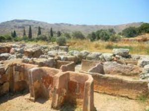
On an area of about 8,000 square metres lie 250 to 300 rooms serving different purposes, among them the royal apartments, craftsmen’s workshops for perfume and luxury goods, water basins – for instance a circular cistern lined with ashlar, seven metres across – and the royal treasury. Around a paved central court of about 30 by 12 metres are grouped the west wing with the cult rooms, the east wing with the living and administrative quarters, and storerooms and kitchens to the north; a second paved court lay to the west. Elephant tusks, faience and copper ingots of the “oxhide” shape bear witness to trade with the East, as do stone bowls from Egypt. Many of the objects found here, including painted amphorae, precious ritual vessels of rock crystal, obsidian and alabaster, and clay tablets in Linear A, can now be seen in the Archaeological Museum of Heraklion. The archive was remarkable in itself: 591 inscribed documents, 31 of them tablets and the rest sealings, a total exceeded only at Agia Triada.
The high level of Minoan civilisation, evident in its architecture, town planning and art, continues to astonish scholars. Some even suspect that the Minoan world may be connected with the legendary Atlantis; to test that theory, however, the Minoan script would first have to be deciphered.
The Gorge of the Dead
Zakros